Habitat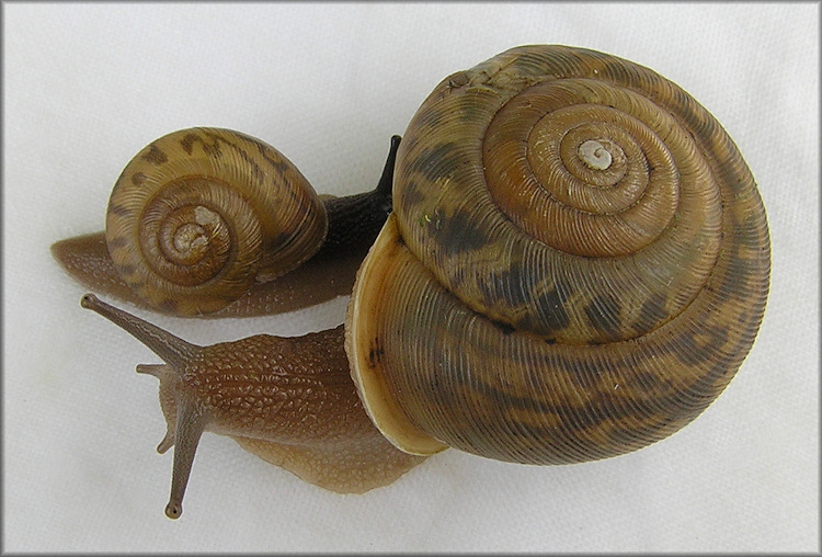
The Appalachina
chilhoweensis can be found in the Great Smoky Mountains in
the states of North Carolina, Tennessee, and Kentucky. The A. chilhoweensis are
found in fairly strict environmental settings. Most are found up
in high in the Appalachian Mountains on wooded slopes that
consist of mixed hardwood forests under leaf litter
(Dourson, 2010). It can also be
found among sandstone boulders of talus
(Dourson, 2010). Talus is a "pile" of rocks that is usually
located at the bottom of a ledge of cliff where a buildup of
sandstone boulders occurs due to environmental causes
(Chandler, 1973). The highest
height the A. chilhoweensis has been recorded is 5400
feet
(Dourson, 2010).
From the sources that were
available at the time I created a map showing the known distribution
of the Appalachina chilhoweensis. The original map that I found on
eol.org had only the three states of North Carolina, Tennessee, and
Kentucky highlighted. This is not very a very precise map because
the habitat of the Appalachina chilhoweensis is in the Appalachian
Mountains located in the Eastern part of Kentucky and Tennessee, and
the western part of North Carolina and not continuously through the
three states. I add information on the county
level which was taken from recorded encounters by Pilsbry
(Pilsbry,
1940). This multivariate map illustrates a more precise distribution
located along the Appalachian Mountains which is produced by
highlighting the counties that A. chilhoweensis has been
found in (Pilsbry, 1940).
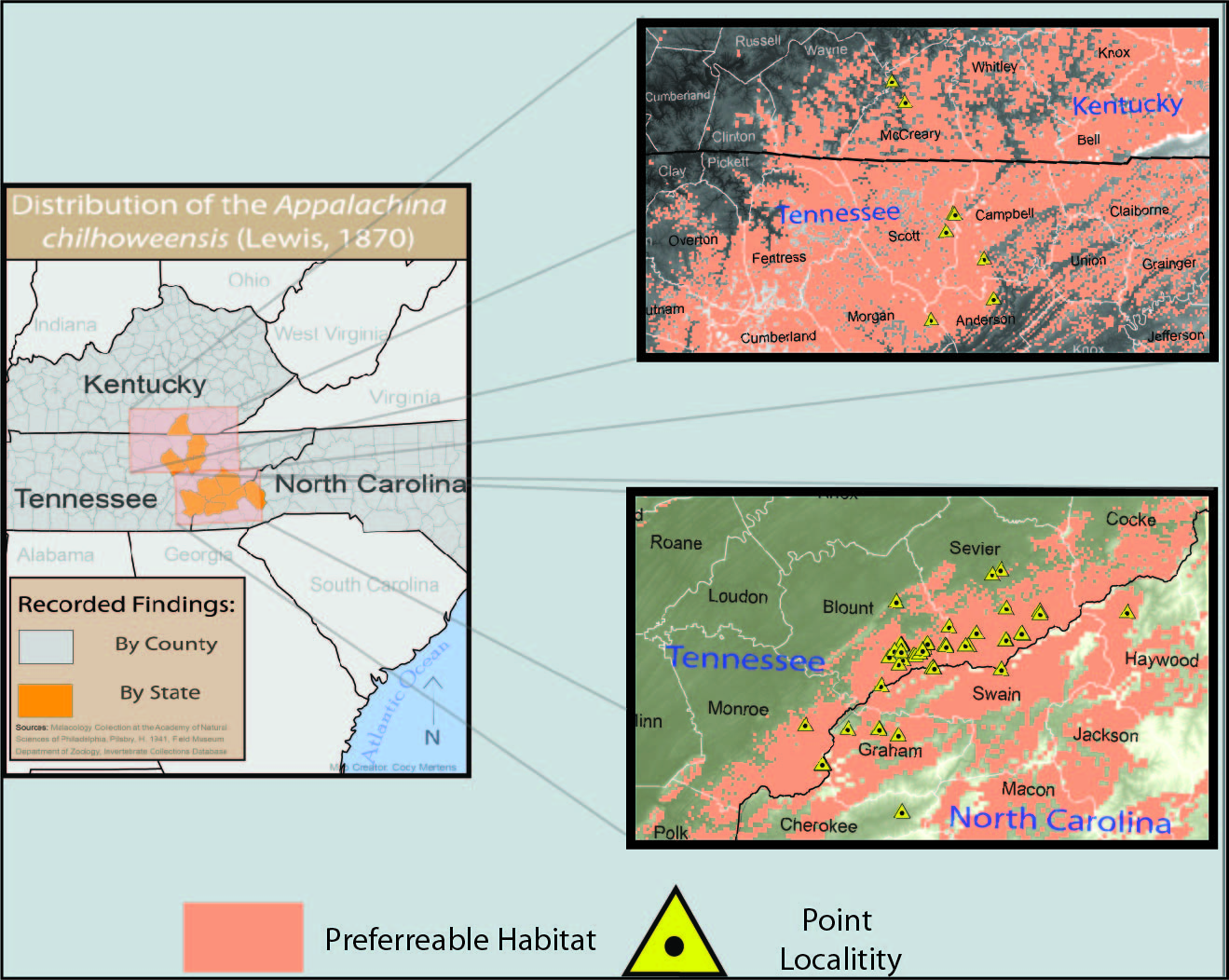
This distribution map was created from a description of habitat
and recorded point localities of the A. chilhoweensis. The
point localities were collected from the Malacology Collection
at the Academy of Natural Sciences of Philadelphia, the North
Carolina Museum of Natural Sciences, the Field Museum, and from
Pilsbry, H. 1940. Each point locality came with a brief description
of were each snail was recorded. Using the description, each
recording was digitized on top of base map. In the same projected
coordinate system as the point localities, layers of geology, cover
type and elevation were used for analysis of habitat type. Since
data for the habitat on the A. chilhoweensis is not very
descriptive, some of the analysis was done from interpreting the the
type of geology, cover type, and elevation that the point localities
were located in. Using a description of habitat and information from
the point localities my parameters for habitat type are:
·
Elevation: 1= 425 m and up for southeast map, and 1=320 m and up for
the northeast corner (due to where localities have been found)
·
Kentucky: geology (1= sand, limestone, sandstone, clay or
mud, conglomerate, black shale, metasedimentary rock, shale) /
covertype ( 1= Deciduous forest, evergreen
forest, mixed forest/ herbaceous, woody wetlands, emergent
herbaceous wetlands)
·
Tennessee: geology ( 1=Chort, clay or mud, sand, limestone,
sandstone, metasedimentary rock, shale, conglomerate, black shale,
migmatite)/ covertype ( 1= Deciduous
forest, evergreen forest, mixed forest/ herbaceous, woody wetlands,
emergent herbaceous wetlands)
· North
Carolina: geology ( 1=Chort, clay or mud, sand, limestone,
sandstone, metasedimentary rock, shale, conglomerate, black shale,
migmatite)/ covertype ( 1= Deciduous
forest, evergreen forest, mixed forest/ herbaceous, woody wetlands,
emergent herbaceous wetlands
The map shows the distribution of the A. chilhoweensis is mostly located up in the Great Smoky Mountains as expected. However, the distribution up the the Great Smoky Mountains is confined to a smaller area than shown by other maps. Also, now looking at the spatial distribution of the point localities a concentration can be seen around the Tennessee and Kentucky boarder, specifically in Blount and Sevier counties.
Using this map for further research would be helpful for locating more A. chilhoweensis while saving time and money. Once more information is gather and a better description of habitat is available, an even more accurate distribution map can be created.
-The spatial data of geology, cover type and elevation were retrieved from the USDA Geospatial Data Gateway. States and county layers that were used for this map were retrieved from the U.S. Census.
Next we will look at Appalachina chilhoweensis nutrition, and see why the A. chilhoweensis is often found under leaf litter!!!
![]()
![]()